


The Meadoway is an ambitious re-naturalization project organized by TRCA and partially funded with a generous donation from The W. Garfield Weston Foundation. The goal: restore 16km of the Gatineau Hydro Corridor - currently a monoculture of lawn that requires constant maintenance - back to a rich, bio-diverse mix of over 40 native species.
Upon completion over 500 acres of land will be restored and will support over 1000 species of birds, insects, pollinators and other urban wildlife.
Working closely with Perkins & Will and TRCA, we developed a suite of visuals that could tell the story and vision of The Meadoway to the community and local stakeholders over the course of 10 months and 3 public meetings. Using a variety of methods including aerial imaging, virtual reality & 3D rendering, the views help envision the full impact of this important restoration project.
Client: TRCA
Role: 3D Rendering, Landscape Visualization, Aerial Photography, Animations
Team: Clint Langevin, Eunice Wong, Paul Kulig, John Slack, Susan Olmstead - Perkins & Will; Corey Wells, Lisa Turnbull, Celene Mariano, Katie Turnbull - TRCA; Jennifer Canham - The W. Garfield Weston Foundation
Year: 2019
Location: Toronto & Scarborough, Ontario
CSLA Award of Excellence
The Meadoway Website
Download the Visualization Toolkit PDF (Full)
Video 1, Video 2, Video 3
All images are property of TRCA. Text adapted from the Visualization Toolkit PDF.
It is important to note that all the visuals as part of this Visualization Toolkit exercise are conceptual demonstrations of the design at this stage. They are proposed for illustrative purposes only and are for conveying the concept and vision for the overall project. They should not be relied upon as final representations of the corridor.
Future Landscapes Design + Visualization and Perkins and Will were retained by Toronto and Region Conservation Authority in 2019 to develop a “visualization toolkit,” from conceptual plans to renderings, animations, and engagement tools to help demonstrate the overall look and feel of The Meadoway.
To summarize the year-long process of developing the Visualization Toolkit, this report was designed to walk through the various stages and tools used to produce the final visuals. From engagement to conceptual sketches, this is a compilation of precedent imagery, existing conditions understanding, and a contextual foundation on which the final visuals are based on.
There are many challenges involved in working on a site that is as large as The Meadoway! To help ourselves and the community grasp the scale and reach of the corridor, we knew we needed a comprehensive site plan.
We began by stitching together high-resolution aerial images as a base. Next we created a master CAD file, with each of the proposed meadoway sections linked within. After exporting the linework and matching it up to the aerial background we began adding textures, shadows and trees to the plan in Photoshop. Then, all of the contextual information surrounding the plan had to be added on both sides, with text, reference images, call-outs and feedback boxes.
Finally the map was printed at 1:1500 scale - resulting in a 24’ long map that was supported by multiple tables. This was hoisted around to 3 different public engagement sessions in 3 different venues. We think all the effort was worth it!
The gateways to The Meadoway are important connective indicators, signalling that something special is happening throughout this 16km space.
The location of this entrance was chosen due to its proximity to the broader community, and the preferred alignment coming up Conlins Road. This span of green open space before the highway creates an enclave condition and gateway. The entrance is near the Pan Am Aquatics Centre and the University of Toronto - Scarborough Campus (UTSC) grounds to the south. With garden features and signage, this will be an identifiable gateway from all directions.
The western gateway provides links to the Pan Am path and Don Valley trail system, leading directly to downtown Toronto. With proposed feature garden planting and connections to the Jonesville community gardens, this gateway serves as a hub for increased community and recreational use.
Starting with aerial helicopter imagery of the site, Susan Olmstead and John Slack at Perkins + Will produced visioning sketches that could both hold the place of more refined visuals and quickly introduce concepts for presentation at public engagement sessions. The sketches served as the models for the renderings, which were refined and revised through multiple rounds of public & internal feedback.
These areas are more ‘passive’ stretches of meadow, where the travelling experience along these portions of trail are peaceful and relaxing, with strategically located areas of rest. With the rolling hills topography west of Morningside Avenue, lookout points could be created at its peaks.
Potential areas for future wetland restoration have been identified throughout The Meadoway. There is an opportunity to restore and enhance these within the corridor, as they are important to the health of our watersheds and communities.
Although these zones are small, according to Toronto and Region Conservation Authority, the benefits of wetland restoration include: increased biodiversity; increased wildlife habitat; improved habitat connectivity; flood attenuation; and improved water quality.
Urban agriculture, as defined by the City of Toronto, is categorized as either community gardens or allotment gardens. Many existing gardens on The Meadoway (e.g. Jonesville Allotment Gardens, Givendale Gardens) are widely used.
Community gardens “provide access to land within the City for groups of people who wish to grow their own plants” whereas allotment gardens are plots that are available with a fee. From public consultation, it was noted that many community members are interested in both approaches to urban agriculture.
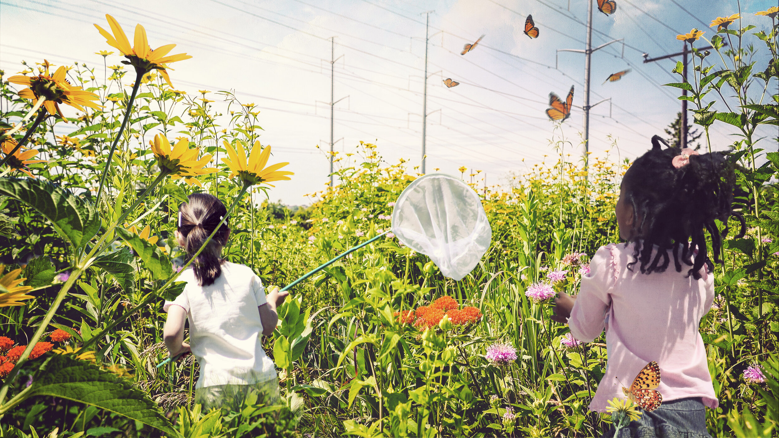
The meadows are full of learning opportunities, especially for children! Toronto and Region Conservation Authority leads education and community learning initiatives for The Meadoway, and many of those explorations look like this!
This visual is an opportunity to demonstrate the naturalized habitat for biodiversity and the beautiful wildflower meadow.
Some north-south trails exist within the hydro corridor and are frequented by residents today. With the implementation of the full Meadoway multi-use trail, the intersections between the existing and the proposed connections will create local community nodes.
These can become meeting points for the community, with identifiable signage and distinct planting. Recreational users of the trail can still easily navigate around these nodes to continue on their journey.
As per the City of Toronto Multi-Use Trail Design Guidelines, crossings should provide “a safe and direct crossing for all trail users...the primary goal is to prevent collisions between users. This is achieved by designing trails with the appropriate alignments and sight lines and by providing appropriate warnings to trail users when necessary”.
As The Meadoway crosses over 30 roadways, each should be designed carefully and consistently to stitch the segments of the corridor together. Amenities such as bike parking and tune-up stations, areas of rest, and signage should be consistently applied to each crossing.
Public engagement is more than just a regulatory requirement, it is a critical part of the design process. A corridor of this length crosses many of Toronto’s neighbourhoods and communities. The Meadoway’s adjacency to schools, community centers, public parks, and places of worship means that the engagement process must be inclusive, extensive, and fully integrated into the design process.
Our approach to engagement went further than just a presentation and panels. We knew that for a project at this scale, it had to be expanded beyond two-dimensions in order for it to be digestible and articulate for the public to understand. Some of the tools we used as vehicles of communication included a 24-foot map, Virtual Reality panoramas, a flipbook and physical models.
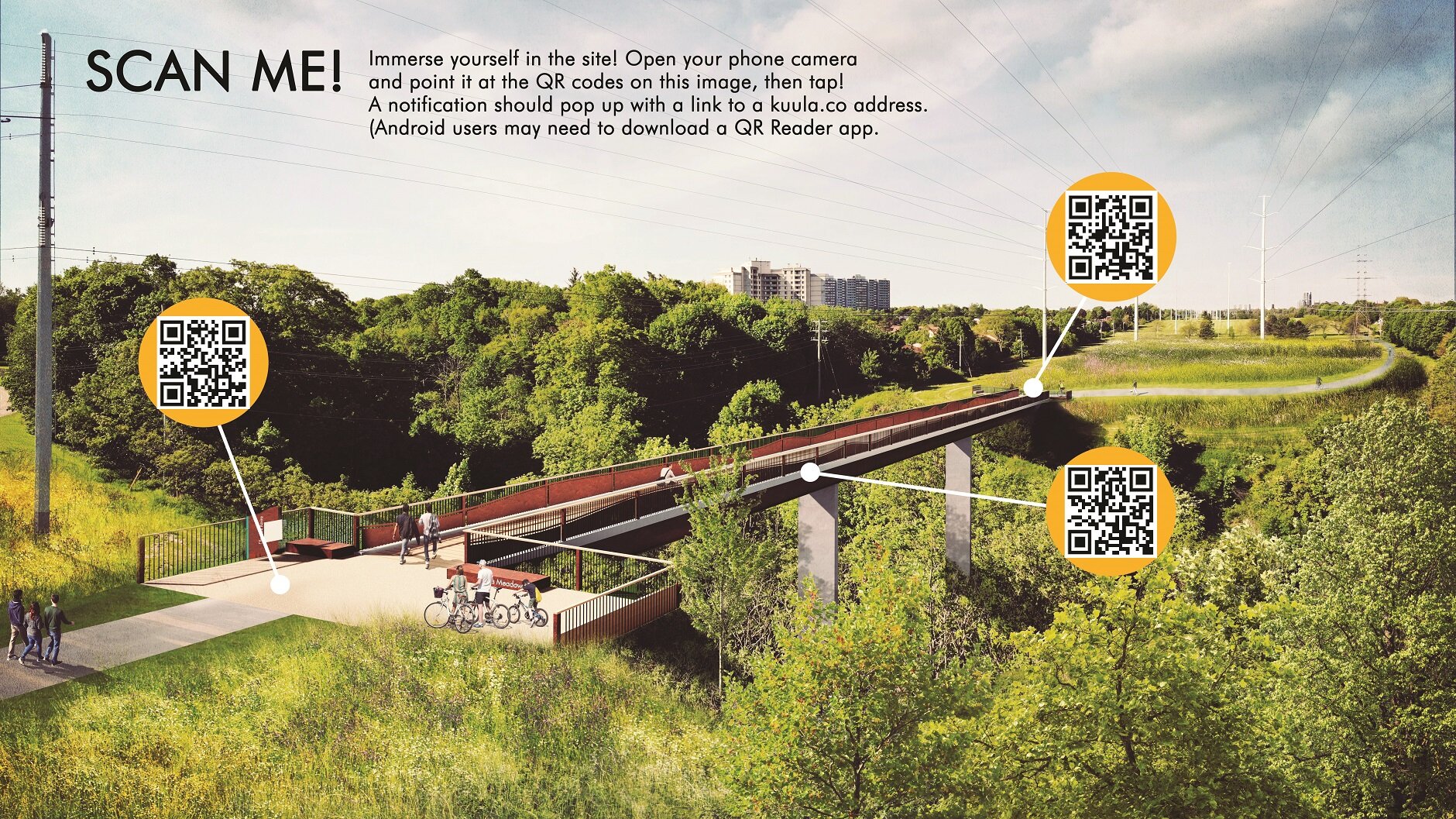
Virtual reality was used by modelling & rendering the site in detail and then creating 3D panos in Lumion. These could be linked online and viewed through any mobile device or through the provided goggles.
The EA (Environmental Assessment) identified a range of potential trail alignments and bridge crossings. The evaluation prioritized objectives such as: provide a positive user experience; protect and enhance natural features; provide connections, and maintain a safe environment.
This rendering of the Ellesmere crossing was to emulate those objectives and demonstrate its critical east-west link. We think this location offers a unique opportunity for an iconic bridge with views over the Ellesmere Ravine.